Recently Viewed ›
Recently Downloaded 
Close x
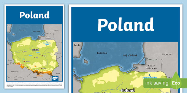
Our KS2 Poland Map is a topographic map showing the relief of the country. The map clearly shows the countries that surround Poland's border, as well as the location of the capital city, Warsaw, and other major Polish cities. The main rivers, the Vistula and the Oder, are shown on the map, as are the main mountain ranges, the Carpathians and the Sudetes.
 map of poland
polish food
poland map
poland activities
poland flag display poster
polish flag
poland banner
poland display
topographic maps
mapa polski
poland flag
all about poland
poland facts
france map
map of poland
polish food
poland map
poland activities
poland flag display poster
polish flag
poland banner
poland display
topographic maps
mapa polski
poland flag
all about poland
poland facts
france map
Our KS2 Poland Map is a topographic map showing the relief of the country. The map clearly shows the countries that surround Poland's border, as well as the location of the capital city, Warsaw, and other major Polish cities. The main rivers, the Vistula and the Oder, are shown on the map, as are the main mountain ranges, the Carpathians and the Sudetes.
This map would be a useful resource for KS2 children to use when learning about the geography of Poland. It could be used for display purposes, research and tabletop activities.
To learn more about Poland, why not download our KS2 Poland Fact File which is packed full of useful facts and information about the country.
We hope that you find the information on our website and in our resources useful. As far as possible, the contents of this resource are reflective of current professional research. However, please be aware that borders on maps may be disputed and information can quickly become out of date. The information here is intended for general guidance purposes only and may have to be adapted to meet the needs of your students.
 Home
Home  Membership
  TwinklCares
  Updated Help for 2022
  Catch-up Resources
  Home Learning Hub
  Create
  Blog
Blog