Weathercatch: 24 years ago today – a crippling storm took region by surprise
It’s not even Thanksgiving Day yet and the Inland Northwest has endured a lot of wind, snow and slush. But 24 years ago today, the weather turned far worse.
Although it’s often called the Spokane Ice Storm of 1996, in reality it was a freak storm that left a trail of destruction across many parts of Washington state and Oregon. Whether you encountered ice, rain, snow – or all of them – depended on where you happened to be on Nov. 19, 1996.
A New York Times headline put it this way: “Severe storms in the Northwest leave 12 dead.” The story, dated Nov. 22, 1996, went on to say that the region was largely taken by surprise, “with record rains in Oregon, unusually early snow in Western Washington and the worst ice storm on record in Spokane.”
About that ice storm. It really hammered the Spokane and Coeur d’ Alene areas, so we’ll revisit that event first.
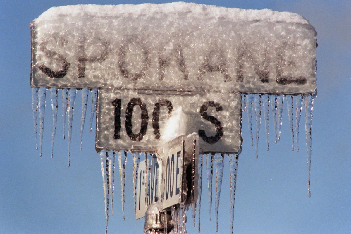
It began when up to 4 inches of snow fell during the night of Nov. 18. Then, early the next afternoon, freezing rain began to fall. A large midlevel atmospheric layer of warmer, above-freezing air had produced regular rain. But as the rain passed through a level of cold air below, it froze to the surfaces it struck, piling a thick, dangerous ice glaze on everything from roads, tree branches and roofs to power lines and traffic lights.
Having freezing rain settle on top of a recent snowfall was bad enough. But the amount of freezing rain that fell made it an especially high-impact weather event. Spokane received 1.24 inches of precipitation that day – one of the largest daily amounts to fall in the area during mid-November. That’s a major daily precipitation amount in any form, but given that most of it fell as freezing rain, the result was one of the worst ice storms in the Pacific Northwest’s history.
Trees and power lines collapsed beneath the weight of up to an inch-and-a-half of ice, causing 100,000 homes and businesses to lose power in Spokane and Kootenai counties for up to two weeks. Three people died and thousands were driven into emergency shelters. Ice-coated trees blocked roadways and ominous icicles hung from roof awnings and utility lines.
The meteorological chaos was the spinoff of a vigorous storm system that tracked across the Pacific Northwest and delivered an alphabet soup of heavy precipitation. Strong rains in Oregon caused deadly mudslides and the flooding of creeks and rivers. In Seattle, a near-record snowfall brought the city and surrounding communities to a standstill.
Meanwhile, 190 miles southwest of Spokane, the city of Yakima – ironically known as the Palm Springs of Washington – received 19 inches of thick, wet snow in 24 hours. Not surprisingly, it remains the city’s all-time record for snowfall.
Nic, a budding meteorologist who lived in Yakima at that time, recalls the forecast ranged from “rain likely” to “rain or snow likely, with minimal accumulation.” Obviously, the magnitude of the impending weather system was unexpected, in part because skilled forecasters had to depend on less-advanced technology than what’s available these days.
But even with modern forecast model ensembles, what happened 24 years ago today illustrates how challenging it can be to forecast wintry precipitation conditions when a temperature change of only a few degrees can produce drastically different outcomes.