SPOKANE, Wash. — Fast-moving showers brought rain, graupel and small hail to the Inland Northwest on Tuesday. The storms that created them also provided some exciting sights.
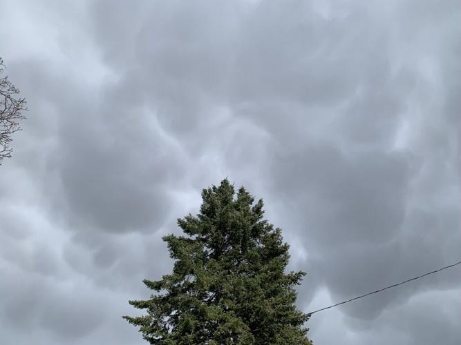
The pouch-like structures on the bottoms of these clouds are called "Mammatus Clouds" or "Mamma." They are usually a sign of a turbulent, unstable atmosphere and happen most often as part of a thunderstorm or cumulonimbus cloud.
Mammatus, and the tops of storms that they form under, are signs that it's time to head indoors. At the very least, their parent storms can bring heavy rain like what happened on Tuesday. At their worst, they can have lighting, hail, and damaging winds like the damaging hailstorm of August 11th, 2022.
Tavis Throm
The exact reason why mammatus form in some cases and not others is not well understood, but studies have shown that the air below the forming mammatus clouds needs to be fairly dry. As storms develop in an unstable atmosphere, large volumes of warm, moist air are lifted tens of thousands of feet. Cold air is heavy and wants to sink, so pockets of this air start to move downward away from the cloud base at the top of the storm. Moist, cool air above warmer, dryer air is a great way to create unstable conditions and pockets of fast-rising and fast-sinking air.
These pockets of sinking air bring part of the cloud along for the ride for a short while, making the upside-down bubble wrap shapes that mesmerize anyone lucky enough to see them.
COPYRIGHT 2023 BY KXLY. ALL RIGHTS RESERVED. THIS MATERIAL MAY NOT BE PUBLISHED, BROADCAST, REWRITTEN OR REDISTRIBUTED.


