What is an unconformity?
An unconformity is a discontinuity in a rock sequence indicating interruption of sedimentation commonly accompanied by erosion of rocks below the break. In other words, it is a break in the geological record, in that previously existing rock or sediment has been worn away before the new layer of sediment has been laid down.
There are several types of unconformities; however, most unconformities belong to one of three main types:
- Disconformity – a break in the laying down of sediment with erosion intervening.
- Angular Unconformity – new sediment is laid down over old sedimentary rock that had been tilted.
- Nonconformity – new sediment is laid down over plutonic igneous or metamorphic rock that has been exposed at the surface.
The figure below shows the tree main types of unconformities:

What is the Great Unconformity?
In 1869, John Wesley Powell led a group of ten men on a scientific expedition down the Colorado River through the Grand Canyon. Powell, who had been a Geology Professor at Illinois Wesleyan University, was very interested in the geology of the Grand Canyon and noticed both a nonconformity where sedimentary rocks overlaid granite and schist, as well as an angular unconformity where the same layers of sedimentary rocks overlaid older, tilted layers of sedimentary rock. He named this feature the “Great Unconformity”.
The Great Unconformity of Powell in the Grand Canyon is a regional unconformity that separates the Tonto Group from the underlying, faulted and tilted sedimentary rocks of the Grand Canyon Supergroup and vertically foliated metamorphic and igneous rocks of the Vishnu Basement Rocks. The unconformity between the Tonto Group and the Vishnu Basement Rocks is a nonconformity. The break between the Tonto Group and the Grand Canyon Supergroup is an angular unconformity.
Powell's Great Unconformity is part of a continent-wide unconformity that extends across Laurentia, the ancient core of North America. It marks the progressive submergence of this landmass by a shallow cratonic sea and its burial by shallow marine sediments of the Cambrian-Early Ordovician Sauk sequence. The submergence of Laurentia ended a lengthy period of widespread continental denudation that exhumed and deeply eroded Precambrian rocks and exposed them to extensive physical and chemical weathering at the Earth’s surface. As a result, Powell's Great Unconformity is unusual in its geographic extent and its stratigraphic significance.
The length of time represented by Powell's Great Unconformity varies along its length. Within the Grand Canyon, the Great Unconformity represents a period of about 175 million years between the Tonto Group and the youngest subdivision, the Sixtymile Formation, of the Grand Canyon Supergroup. At the base of the Grand Canyon Supergroup, where it truncates the Bass Formation, the period of time represented by this angular unconformity increases to about 725 million years. Where the Tonto Group overlies the Vishnu Basement Rocks, the Great Unconformity represents a period as much as 1.2 to 1.6 billion years of time.
This Earthcache
Is the Grand Canyon the only place to see the Great Unconformity? No! It can be seen in very many places around Payson! It is found in the East Verde River valley, and all along Houston Mesa, and Diamond Rim, as well as many other places around town, even within Payson City limits (Airport Road, Gold Nugget Lane, et. al.).
This earthcache is just off Highway 87 where it crosses the East Verde River. Take the road south where 87 crosses the river and immediately turn into the parking area on the right. Walk down toward the river from the parking lot and look at the cliff face across the river. You will notice a distinct line where sedimentary rock (Tapeats Sandstone) directly overlies granite (Payson Granite).
Payson Granite was emplaced as a pluton deep in the earth’s crust some 1.7 Billion years ago. Over eons of time, it was lifted and the overlying strata were weathered and eroded away until the granite was exposed. The surrounding land was eventually levelled by erosion for hundreds of miles in every direction until it was a broad, low coastal plain. This plain subsided and was slowly covered by ocean. As this happened, poorly sorted sand was laid down along the advancing beach, covering the bare granite. This process began about 525 Million years ago.
Over time, this sand was subsequently covered with additional sediments that made up the Martin Formation, Redwall Limestone, Naco Formation and others. These sediments were lithified into the rock they are today.
Look across the river to the cliff face. The rock forming the bottom 30 – 40 feet of the cliff is Payson Granite. Above it is Tapeats Sandstone. You can easily see sedimentary layers in the sandstone, but no such layers exist in the underlying igneous rock. The line that separates the two is the Great Unconformity.
To claim credit for this geocache, please send me the answers to the following questions.
- Which of the three main types of unconformities do you see before you? Why do you say so?
- How old is the rock just below the Great Unconformity here in Payson?
- How old is the rock just above the Great Unconformity here in Payson?
- Taking the difference between the ages of the two rocks, how many years of the geologic record is missing here?
Go ahead and log your earthcache after sending your answers. In the event that the answers are not received within seven days of logging, I will be forced to delete your log.
Note
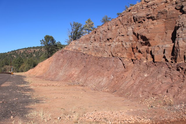
If you drive from Payson to this earthcache, please take note of a road cut just north of Payson where Highway 87 begins its curve to the west. This is the most spectacular display of the Great Unconformity in this region; however, ADOT will not allow an earthcache at this location as it would constitute an encroachment, and would be dangerous for pedestrians to be in a location where pedestrians are not expected.