Note: There is no physical box to find. Read below and complete the tasks to log this as a find.
The Southern Gulf Islands and the lower Vancouver Island region are made of a soft, clastic sedimentary layer six kilometers thick in some parts. Included in this layer are bands of sandstone, mudstone, conglomerate and coal. These sediments were deposited during the Cretaceous period approximately 85-65 million years ago.
History
The Malaspina Galleries were well known to the First Nations people for centuries and were discovered by Spanish naval officers Dionisio and Alcala Galiano and Cayetano Valdes y Flores in 1792. This expedition was conducted by these two captains, who felt the survey of the northwest coast of America was overdue, on the vessels Mexicana and Sutil(BCGNIS). The story that Captain Galiano sketched these galleries is apparently a misconception (Doe 2008).
An artist's representation of what the original sketch looked like. The original was unfortunately lost.
Geology
Sedimentary rocks are one of three classes of rock. Sedimentaryrock is broken into three sub classes below:
- Clastic- These rocks comprise of existing rock compressed under immense pressure.
- Biogenic- These rocks are formed from the remains of living things.
- Evaportic-These rocks are made out of dissolved minerals in water which have been precipitated out of solution.
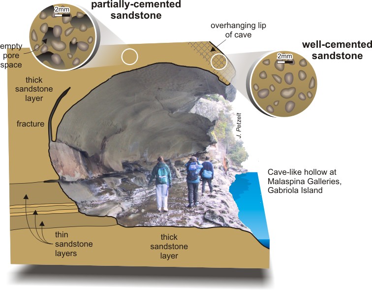
This feature was formed through differential weathering in the sandstone. Unlike sea caves, these galleries do not appear to be formed primarily by crashing waves. There are no barnacles on the back wall and the tide rarely (if at all) floods high enough the submerge the walkable ledge. The clay in the sandstone that cements the particles together is vulnerable to salt water attacking them. The amount and size of voids determine the strength of the sandstone. The "visor" component of the geological feature contains fewer voids and as a result the cement in stronger than the lower portion. As salt water seeps into the sandstone, either from the top or from the crashing waves, the rock behaves much like a sponge, and regular weathering is accelerated because of the weakness in the rock. This salt water attack is believed to be caused by the expansion of the salt after the water has evaporated, which then chips flakes of sandstone off. The seas can get quite stomy of Gabriola Island and the power of crashing waves is immense.
Source: CGEN archive
References
Logging Requirements
Disclaimer: The galleries are in a contant state of erosion and thus are unstable and will collapse one day. There is also a parks sign advising against walking underneath along the ledge. No logging requirements ask you to walk in. Proceed as your comfort level allows.
1.) Upon close observation, would you say that the rock formationis sandstone, mudstone or conglomerate?
2.) What range of sizes in the sedimentary particles do you see?
3.) Describe the striations (if any) or any other strange layers or lines you see.
4.) Estimate how much the cavity is eroded per year.
5.) Optional:Take a picture of you and your GPS with the galleries in the background.
These answers must be E-mailed to me to qualify for the log. Please send answers to my E-mail through my geocaching.com profile