

Antiquaries had been aware of what we now call ‘crop marks’ for some 400 years before aerial photography came of age. John Leland, visiting Silchester in 1540, recorded the fact that ‘in certain partes of the ground withyn the waules’, the corn suddenly ‘decayith’ just as it begins to ripen. Leland does not seem to have understood the reason for this sudden withering, whereas William Camden, writing in his Britannia some 50 years later, recorded ‘what the inhabitants of this place told me’, viz that ‘it had been a constant observation of theirs that though the soil here be fat and fertile, yet in a sort of baulks that cross one another, the corn never grows as thick as in the other parts of the field; and along these they imagine the old streets of the city to have run’. John Aubrey was the next antiquary to record the phenomenon, again at Silchester, though he did not observe it himself; instead he informs us that ‘two learned prelates’ (thus unlikely to be making it up) ‘did affirm that one might discern in the corn-ground the sign of streets, passages and also of hearths’. The frequency of such observations grows ever more numerous as the centuries wear on, so that by the 19th century, crop marks are presented as a matter fact by Romantic poets celebrating the mark of the past upon the land. The first volume of poems composed by Jane Austen’s contemporary Mary Russell Mitford (1787-1855) and published in 1811, described:
That land where once a city fair
Flourished and pour’d her thousands there,
Where now the waving cornfields glow
And trace the wide streets as they grow
Oh chronicle of ages gone…

John Kenyon (1784-1856) was struck by the same thought and wrote, in a poem called ‘Silchester’ (1838):
Yet eyes instructed, as along they pass,
May learn from crossing lines of stunted grass
And stunted wheat stems, that refuse to grow,
What intersecting causeways sleep below.
It is, though, quite a step from poetic conceit to scientific understanding and the development of systematic techniques for recording and interpreting crop marks. That can perhaps be dated to the 1890s, beginning with a letter published in The Times on 12 August 1893, written by Walter Money of Newbury, a Fellow of the Society of Antiquaries – the learned society founded in 1707 to encourage and further the study of Britain’s past. Money recorded that ‘due to the abnormally dry season which has prevailed’, the attention of Henry J Hewitt, tenant of Northfield Farm (located about a mile south-west of Dorchester-on-Thames) ‘was arrested by the increased fertility of the crops in certain parts of the field, which in outline indicate in a most distinct manner a block plan of supposed foundations of buildings and boundaries of roads, of such a vast extent and variety of form as to be at first sight almost bewildering’.

Rather than simply reporting the phenomenon, Walter Money persuaded Mr Hewitt to ‘employ a professional surveyor to make a plan of the ground, in order that after the harvest we may be enabled to learn something more as to the character of these supposed vestiges of the early conquerors of Britain, who undoubtedly had an extensive settlement in this locality’.
Buried secrets
Farmer Hewitt seems to have become infected by the archaeology bug because he subsequently ‘commenced excavations, and continued them at convenient periods for the next three or four years’. The last quote comes from a report written by another Fellow of the Society of Antiquaries, Francis Haverfield, who made regular visits to these ‘diggings’, and concluded that they were of a ‘late Celtic or Roman village’. His lecture to the Society concluded that ‘the lines and patches where the crops grew richer and taller correspond to pits and trenches sunk in the gravel and filled with clay or with other soil which retains moisture longer than the gravel does; hence in time of drought the superior richness of the crops above’.


He went further in proposing that ‘the same lines and patches, rectangles and circles, can be detected in dry summers in other low-lying places in the Upper Thames Valley. The list of sites I have collected is the result of sporadic enquiry and personal search, but is enough, I think, to show that the phenomena of Northfield Farm are the phenomena not of a single site… but of a large area of country’. Summers continued to be hot and dry throughout the 1890s and into the first decade of the 20th century, and similar ‘marks of forgotten antiquities’ were recorded all over southern Britain, including parch marks in Salisbury Cathedral Close where buried headstones and the foundations of a long-forgotten bell tower were revealed.
Those who went out in search of such marks also observed that slight earthworks, ploughed almost level, could be picked out in the landscape by the shadows cast when the sun was low, and that all these phenomena were best viewed from a high vantage point. Thus Arthur Evans, President of the Society of Antiquaries, contributed his own letter to The Times, on 23 September 1893, saying that on a recent walk to the ‘old British encampment known to modern antiquaries as Sinodun [Castle Hill, Wittenham Clumps, Oxfordshire] he had looked down on ‘the curious outlines of an ancient settlement recently revealed in the barley by the dry season… in which the round huts of the Britons are seen before our eyes, yielding to the rectangular buildings and enclosures of the later Romanised inhabitants.’

Archaeological hot air
The last decade of the 19th and first decade of the 20th centuries happened also to be the period of the ballooning craze all over Europe, and the first experiments with aerial photography. Archaeology was not the specific focus of this activity: the few images we have from that period include archaeology by accident rather than design, such as the famous 1906 images of Stonehenge, taken by Lieutenant P H Sharpe, of the Royal Engineers, probably on 18 June, probably from a balloon tethered to the spot by ropes held by the ground crew. Pictures that have now come to enjoy iconic status as the first aerial photographs of an archaeological monument in Britain were probably taken to test out a newly acquired camera, and when the resulting photographs were first exhibited at a meeting of the Society of Antiquaries on 6 December 1906 they were regarded as curiosities and novelties, rather than a new and potentially revolutionary tool for analysing the historic environment.


That realisation was not to dawn for another two decades, after the period of accelerated development in flying and photography that resulted from the First World War, combined with the doggedness of the first Ordnance Survey (OS) Archaeology Officer, O G S Crawford. Nothing in Crawford’s wartime experience or his early years of employment at the OS led directly to his subsequent passionate advocacy of aerial photography. Instead there seems to have been a moment of sudden insight that occurred in 1922, when he was invited by his friend Dr J P Williams-Freeman to look at a series of aerial photographs taken in May of that year by pilots based at RAF Weyhill.
At this stage Crawford was wrestling with contemporary ideas about the differences between so-called ‘Celtic’, Roman and Saxon fields. What he saw when he looked at the Hampshire photographs, he later wrote in his autobiography Said and Done (1955), ‘surpassed my wildest dreams. I felt much the same excitement as, according to the poet, did stout Cortez on a memorable occasion [the reference is to Hernán Cortés, portrayed in a poem by Keats as the first European to set eyes upon the Pacific Ocean]. Here on these photographs was revealed the accurate plan of field systems that must be at least 2,000 years old, covering hundreds of acres of Hampshire’.

Crawford chose to share his new understanding of the power of aerial photography as an archaeological tool by means of a lecture at the Royal Geographical Society, deliberately avoiding the Society of Antiquaries because the Fellows ‘had always appeared to be rather bored by prehistory’. He was pleased with his own performance, which ‘established my reputation in the eyes of the world’, and he followed it up with an article that was published in the Observer on 22 July 1923 under the headline ‘Air photography vindicated’ announcing that he had made a major new discovery at Stonehenge. Then as now, Stonehenge was guaranteed to grab the headlines.
Deception from above
Interpreting aerial photographs requires knowledge and skill, and Crawford always insisted that features detected from the air needed to be checked on the ground – the so-called ‘ground-truthing’ of modern archaeological parlance. In the picture below, looking just like a barrow cemetery, is the gas-testing range built on Wiltshire’s Porton Down in 1906 to investigate the behaviour of chemical weapons, such as mustard gas, including the effect of wind on the direction of the gas concentration and flow. To complicate the interpretation, a genuine prehistoric ditch and Bronze Age barrows can be seen in the bottom centre of the picture.

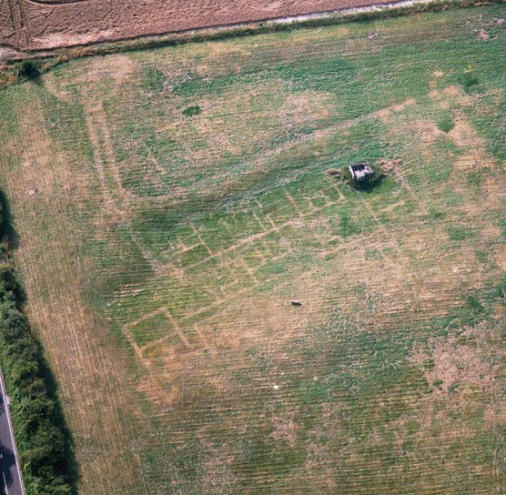
Below is another trick picture: easily mistaken for a Roman villa, the parch marks in this photograph of 15 August 2003 actually show the buried remains of a WRAF accommodation block from the Second World War.
Defensive earthworks
The article announced that he had been able to trace the course of the Avenue, hitherto unmapped and little understood, beyond the limits of the surviving earthworks. Instead of ending at Kings Barrow Ridge, as previously thought, Crawford explained that the full course is plainly visible on air photographs as a pair of thin parallel white lines, and that ‘it bends sharply south-eastwards, and then, after a straight run of just over half a mile, terminates abruptly (in the hamlet of West Amesbury) on the banks of the Avon.’ Crawford went on to say that ‘all this is absolutely new and was never before suspected; and there can be no reasonable doubt that this is correct… but I do not expect others to be convinced until trenches have been dug across to prove it’.
If Crawford’s words seem defensive, that is perhaps because his own new-found enthusiasm for aerial photography did not seem to be shared by his Ordnance Survey colleagues. Crawford believed that aerial photographs had the potential to ‘save a great deal of time and public money during the revision of large-scale maps, for they show exactly where new or suspected earthworks are to be looked for, and thus they save one hours of fruitless search.’ The OS responded with the tactic employed by all bureaucracies when they want to kill an idea: they set up an Air Survey Committee. This supervised various experiments designed to evaluate techniques for producing accurate maps from aerial photographs, and this work continued in a low-key manner right up to the outbreak of the Second World War.

Crawford might have been despondent had he not been galvanised by the support of Alexander Keiller, heir to the Dundee-based marmalade manufacturing company, who read Crawford’s Observer article and wrote to him offering to finance ‘a special exhibition to take archaeological air photographs from a hired aeroplane’. Perhaps the indifference of the OS to aerial photography worked to Crawford’s advantage on this occasion, because he not only gained permission to work with Keiller on the project, and to keep an aeroplane for the purpose at RAF Weyhill, but also to visit sites on the ground that had been photographed from the air, and write them up during office hours. In fact, Crawford later wrote, ‘I could not help feeling that neither he [the Director General] nor anyone else in the office really cared how I spent my time, provided I kept quiet and didn’t worry them with new ideas.’
The result was the ground-breaking Wessex from the Air (1928), featuring 50 photographs of earthworks and what Crawford referred to as ‘streak sites’ (both crop marks and differences in soil colour caused by the ploughing of field monuments), analysed and mapped in such a way as to demonstrate how much knowledge could be gleaned from an aerial image when set in the context of previously recorded finds, excavation records, and historic documents, including estate and tithe maps. It was the book in which Crawford introduced the term ‘palimpsest’ to describe the complexity of the historic environment, and the changes that have been written upon it by human activity over and over again, surviving as a puzzle to be understood and unravelled.

Only the year before, in 1927, Crawford had established the new journal Antiquity as a quarterly periodical that would reach beyond the academic archaeological community to convey the results of new discoveries to non-specialists. Antiquity was to play a key role in promoting aerial photography ‘as a powerful aid to the advancement of Knowledge’. Once again it was the Stonehenge landscape that powerfully illustrated the potential for revealing ‘lost or unsuspected remains’ in an early issue of the journal. This time, it was the discovery of the site that came to be known as Woodhenge, photographed from the air by Squadron Leader Gilbert Stuart Insall VC. Insall was a war hero and dare-devil pilot with a passion for archaeology, who took a series of photographs of the site from December 1925 to June 1926. Intrigued, Insall felt that the site appeared to be far more than the ‘mutilated disc-barrow’ of earlier descriptions. Insall’s photographs encouraged Maud Cunningham to undertake excavations between 1926 and 1929, describing the site as ‘the most sensational archaeological discovery [yet] made by means of photography from the air’.
Flying high
Crawford continued to cultivate RAF officers that he encountered during his OS work, encouraging them to report unusual crop marks and plough marks, as well as making suggestions to them of places or sites that he would like to see photographed. RAF pilots were happy to oblige because this gave a focus to their training flights, and they found that the skills involved in the pinpointing and photography of very small sites was good training for bombers and pilots. For once, the bureaucrats of the Air Ministry and RAF were happy to allow this work ‘from time to time as opportunity occurs’, because they recognised that such work ‘can be genuinely worked into training flights without appreciable extra expense to the Royal Air Force’.

What the RAF would not do, at this stage, was provide the sort of total systematic coverage of the entire British landscape from the air that we now take for granted, thanks to subsequent developments in satellite photography and computer algorithms for transferring photographic data to a flat map. Alexander Keiller was an enthusiast for such a project, imagining that it could best be carried out from an airship, ‘so slow and so large, you could plot sites straight on to six-inch maps – and it’s even got a bar!’ Crawford was more of a realist: in 1939, just before the outbreak of the Second World War, which was to accelerate and revolutionise aerial reconnaissance, he applied for permission to take aerial photographs of Roman sites in Scotland as part of the Ordnance Survey’s map revision programme. Those who had supported his earlier efforts in this field had long since retired. ‘My application’, wrote Crawford, ‘caused a flutter of apprehension in the bureaucratic dovecotes, and the usual lengthy exchange of minutes… I was asked to say how much it would cost to do the same work by taxi.’
In the end Crawford paid for the work out of his own pocket, noting that so many crop-mark sites were photographed as a result that it was impossible to record them all and that ‘the exploration of ancient Scotland from the air… is one of the most promising fields of research anywhere in the world’. All Crawford’s aerial photographic activities were put on hold for the duration of the war, and Crawford himself was employed photographing buildings of architectural or historical interest deemed to be at risk of bombing for the newly established National Buildings Record. He retired in October 1945, having been the leading figure and champion of aerial photography for more than two decades, struggling against ignorance and scepticism that was finally blown away by the war. Propagandists lauded the airborne camera as a ‘one-eyed Mata Hari for the Blitzkrieg era’, able to spy on enemy territory without need of ‘false passport, whiskers or invisible ink.’

German intelligence understood this too, and one of the great prizes that the Allies sought to gain in the closing months of the war was the massive central archive of negatives and prints of aerial photographs that the Luftwaffe had built up through aerial reconnaissance since its establishment in 1935. With the Russian army closing in, the archive was deliberately torched by German defenders. But British troops stumbled across a vast back-up archive in Bavaria that was flown to RAF Medmenham for appraisal and has since proved invaluable to archaeologists and historians. Among those who spent their war years working on aerial photographic interpretation at Medmenham were Glyn Daniel, Crawford’s successor as Antiquity editor; Stuart Piggott, future Abercromby Professor of Archaeology at Edinburgh University; Dorothy Garrod, future Disney Professor of Archaeology, and the first ever female professor at Cambridge; and Charles Phillips, fresh from excavating Sutton Hoo. It was thus to prove a fertile training ground for the next generation of archaeologists, who needed no persuading that aerial photography was going to be absolutely central to the future development of the discipline.
Further reading
Mata Hari’s Glass Eye and Other Stories: a history of aerial photography and archaeology by Martyn Barber, ISBN 978-1848020368, English Heritage, £25.
All images: English Heritage Archive, unless otherwise stated.


You must be logged in to post a comment.