
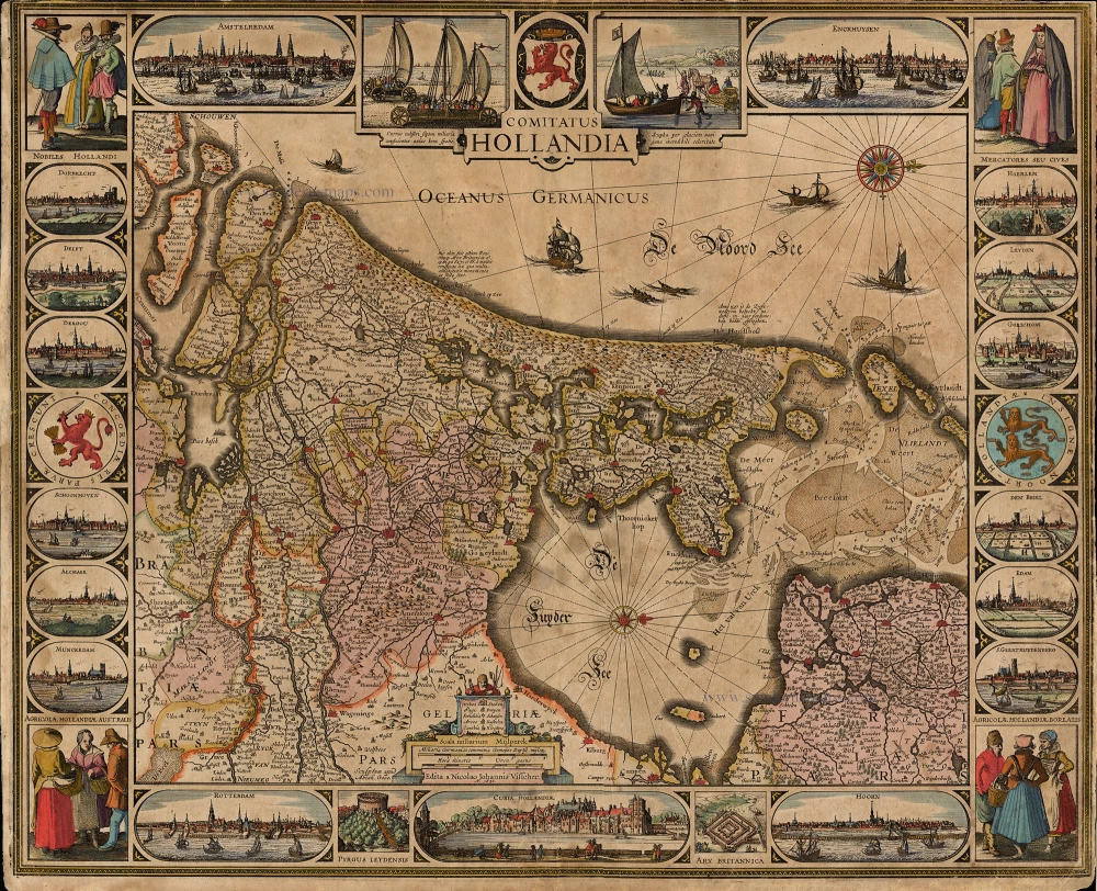
Antique map of Holland by Visscher C.J. 1630
Tabula Frisiae Groninghae et Territory Embdensis nec non circumjacentium Regionum puta Transisalaniae, Benthemiae, Westphaliae, et Oldenburgi, noviter summa cura et studio edita, à Nicolao Iohannide Piscatore. A°.
Item Number: 19077 Authenticity Guarantee
Category: Antique maps > Europe > The Netherlands
Copper engraving
Size: 47 x 58cm (18.3 x 22.6 inches)
Margins: Left: 5 - 7mm, Top: no margin, Left:3mm, Bottom: 10mm
Verso: Blank
Condition: Old coloured, tears skilfully repaired, age toned.
References: Schilder 6, 73. First state; Blonk D.I., 44.
Separate publication.
"The title appears in the centre of the top border below the coat of arms of the County of Holland. To the left of the bottom centre is a cartouche decorated with a fisherman, and containing the legend of symbols, the scale and the imprint. To the left of this cartouche the map engraver Abraham Goos is mentioned. West is at the top; a compass rose is shown in the North Sea and the Zuiderzee.
The map is framed on all sides by decorative borders. The top border shows two town views and scenes with wind-powered wagons on the beach and an ice-sledge. The bottom border delineates town views and archaeological sites. The side borders show costumed figures, town views and coat of arms.
For the border decorations the etcher copied well-known motifs from older maps. The drawings of the wind powered wagons and ice-sledge are based on those on Visscher's 1622 Leo Hollandicus; the female figure at the far right in the scene at the upper right, and the two female figures at the lower right, are based on similar figures at the upper right on the same map. Prints by Jan van de Velde served as the models for other figures in the corner scenes. Seven town views were copied from those by Claes Jansz Visscher on Willem Jansz's 1608 map. There are, however, some small differences, especially in the foreground.
The geographical content of this Visscher map still derives from Van Deventer's mapping, even though the new wall map by Balthasar Florisz van Berckenrode, with completely new geographical content, had already been published in 1621. The engraver of the Visscher map generally copied the 1608 Willem Jansz map, but made some small alterations in the northern part of Holland. The Beemster and Purmer are shown as reclaimed areas, but without a network of roads. The Wieringerwaard, however, is drawn in as a polder with roads. The Wormer, whose inpoldering was finished in 1626, is still shown as a lake.
The map was engraved by Abraham Goos, the decorative borders etched in Visscher's workshop. The map is mentioned as Hollandia Comitatus in Nicolaas Visscher's c. 1682 stock list." (Schilder)