If you boat among the 30,000 Islands of Georgian Bay you are well aware of the many hidden rocks and shoals that seem to wait, daring you to come their way. A couple of days ago I saw a 40-foot power boat onshore with its bow ripped apart following an unadvised shortcut between channels. That’s life exploring the Georgian Bay Biosphere. Stay in the small craft route and you are guaranteed to have no surprises. Wander off the ‘beaten track’ into the more interesting areas and you take responsibility for what happens.
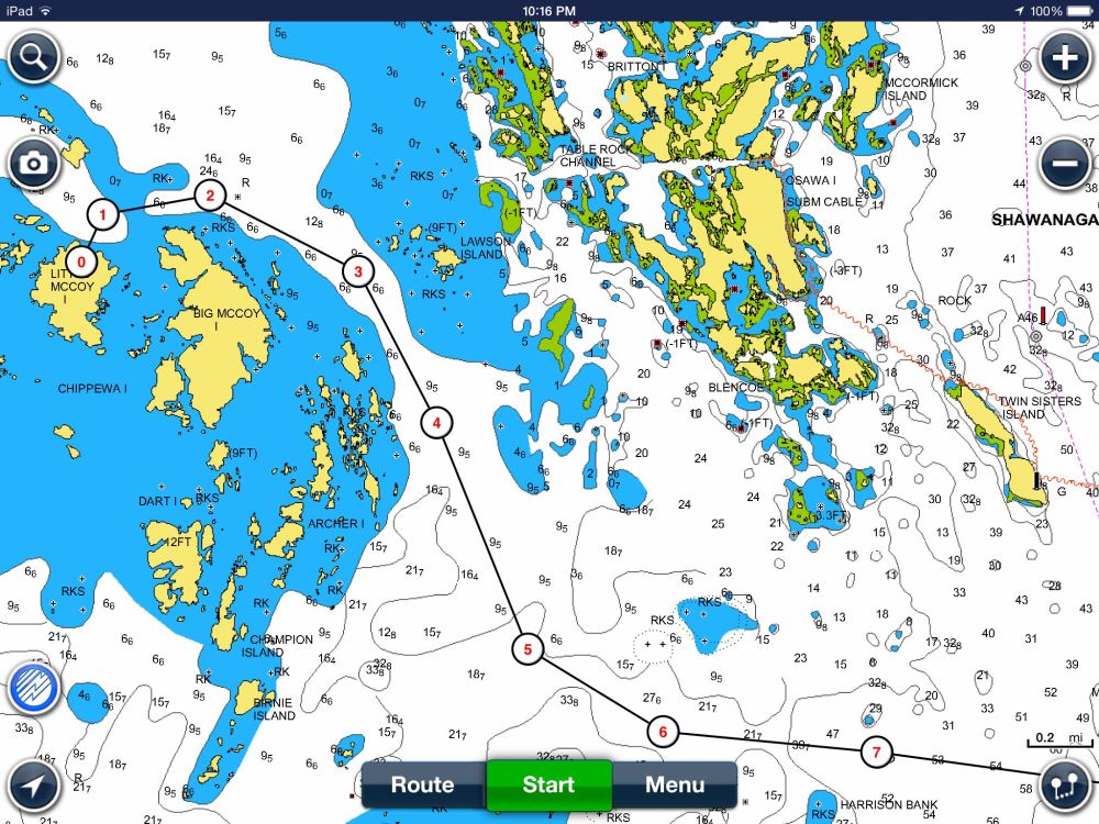
In a series of reviews last year I looked at how iPad apps from Navionics, iSailor and iNavX made it much easier to head off the small craft routes and explore some of the thirty thousand islands. Well these apps are great but they are not perfect as I found out last weekend on a trip from Parry Sound to Little McCoy Island (45.458303, -80.481705). This was a new destination for us and I spoke with couple of people about the best route to take as well as consulting with the Navionics and iSailor apps on my iPad. On route I was careful to ensure I stayed on my planned route using the Navionics app. Here’s a snapshot of the path once beyond the charted small craft route. The darker blue represents a depth of less than 6 feet while white represents depths of more than 6 feet. Boating with our 21-foot Scout and 150-hp Yamaha outboard I’m pretty comfortable with depths of 4-feet or more, and right now we are dealing with water levels at or slightly above chart datum.
 Heading west of Franklin Island towards Little McCoy.
Here’s a closer look as you approach the McCoy’s. It’s pretty obvious that there is a safe seam running east of the McCoy Islands with issues just as you approach Little McCoy Island. Or so you would think.

On the way in I managed to ding the prop, not too seriously, about where you see the Number 2 on the Navionics chart. (Click image for a larger view.) On the way back I suffered a separate ding, at higher speed, between points 3 and 4. According to the charts I was in an area that should have had more than 6-feet of water. In particular the ding beyond point 3 (heading south) was a surprise, as evidenced by the fact that I was confidently moving at about 40 kph (25 mph) – ouch, ouch, ouch. There had been no problem on the way in and I was pretty much on the same track. (That’s another nice feature of Navionics and iSailor, you are able to lay down a track that you can follow when returning.)
Now about Google Earth. In this part of the world Google Earth and Google maps have on and off coverage, here’s an example of the area around Franklin Island and the McCoys. In those areas where there is a stretch of open water they generally choose to blur out the area with a not very aqua blue. (Hey it’s just water what else is there to show?)

Looking closer (below), Google Earth can explain what I ‘discovered’ on my way in and out of Little McCoy. It’s pretty obvious that there is a seam in the channel that is consistent with the Navionics charts. But they are not perfect seams as you can see looking a little closer. I’ve tried to approximate the ‘ding points’ on the Google Earth projection and you can see what I discovered with the bottom of my outboard. What Navionics didn’t catch were the several shallow points in the area identified as 6-feet or deeper. No criticism of the app, they can’t be expected to have information on every square foot of Georgian Bay.

What is interesting is the area north of Big McCoy Island (below). Contrary to what is indicated by Navionics it seems the safer route is closer, not further away, from the island.

Lesson learned and a look at Google Earth will be part of my standard operating procedure when wandering too far off the well charted areas. Actually I will pay better attention to the Google Earth information and plot some of the more challenging points on the Navionics charts. The irony is that I did look at the Google Earth maps before heading out but failed to look close enough and map it against the Navionics chart data.
Google Earth and Navionics seem to be a natural fit and worth exploring before heading out. Whatever type of ding the prop and skeg took it didn’t impact performance on the way back, but I haven’t yet had the courage to tilt the engine forward and take a look.
JB – Communications Officer
Reblogged this on The CPS Boating Resource and commented:
Do you use Google Earth as part of your pre route planning? It might help you avoid some dings. Read more here: