
Images


January 5, 2022 - Amazon Rainforest
 Tweet
Tweet
The Amazon rainforest has been called a “place of near-mythical status”, filled with green vegetation, towering trees, wide rivers, and alive with creatures of every description—from howler monkeys and blazingly gorgeous birds hiding the canopy, to jaguars on the prowl, to bright-colored poison-dart frogs camouflaged on the moist forest floor. Stretching over about forty percent of South America, the Amazon spans eight countries, including Brazil, Bolivia, Peru, Ecuador, Colombia, Venezuela, Guyana, and Suriname as well as French Guiana, which is an overseas territory of France. The dense forests are estimated to span 1.4 billion acres and give home to one in ten species known on Earth, and some species that have not been fully described. According to the World Wildlife Fund, the Amazon is home to 40,000 plant species, 2,400 freshwater fish species and more than 370 types of reptiles. Just to illustrate the incredible biodiversity, 610 species of birds are found in the Yasuni Biosphere Reserve alone, a park of only 1.6 million hectares located in northern Ecuador.
The Amazon is critical to our Earth’s well-being not just for the intense biodiversity, or the richness of the soils, or the spiritual connection found by many in the deep rainforest setting. The Amazon rainforest also plays a vital and critical role in moderating global warming, thanks to the dense vegetation which absorbs millions of tons of carbon emissions each year. Deforestation—which removes the carbon stored as biomass and releases it into the atmosphere while reducing forest size—is a major threat to the rainforest and to the health of the Earth. Another threat requiring mitigation is the drying of the Amazon’s humid rainforests as an effect of climate warming.
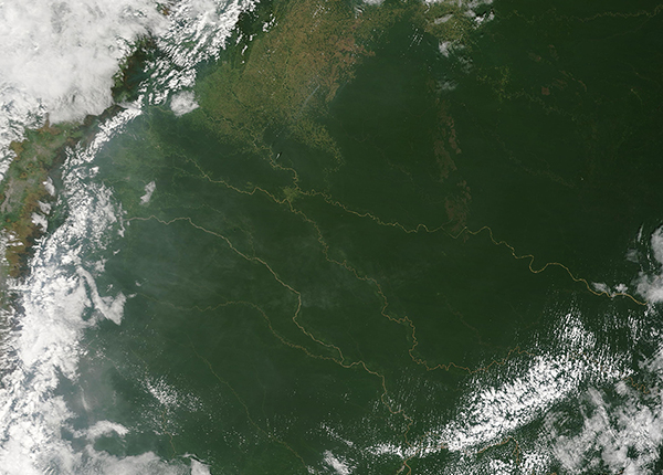
On January 3, 2022, the Moderate Resolution Imaging Spectroradiometer (MODIS) on board NASA’s Terra satellite acquired a true-color image of the Amazon. This view includes parts of Ecuador (southwest), Colombia (north) and Brazil (east). The Andes Mountains of Ecuador and Colombia can be seen near the left (west) edge of the image, with clouds covering the western face of the mountains. Numerous tan-colored rivers, rich with sediment, flow from the mountains into the rich, dense green of the rainforest.
Gray haze, suggestive of smoke from fires, hangs over the southwestern section of the image. While this image does not highlight the hot spots typical of actively burning fire, when thermal imagery is added as an overlay, it is clear that the gray haze is indeed smoke. The smoke rose from multiple fires burning in the agricultural areas (light green) near Florencia, Colombia. Many fires appeared to sit at the edge of the rainforest of that country, while others were in agricultural fields. According to Global Forest Watch, the fire season in Florencia generally begins in mid-January and lasts for ten weeks.
Image Facts
Satellite:
Terra
Date Acquired: 1/3/2022
Resolutions:
1km (709.4 KB), 500m (1.9 MB), 250m (1.3 MB)
Bands Used: 1,4,3
Image Credit:
MODIS Land Rapid Response Team, NASA GSFC
The Amazon rainforest has been called a “place of near-mythical status”, filled with green vegetation, towering trees, wide rivers, and alive with creatures of every description—from howler monkeys and blazingly gorgeous birds hiding the canopy, to jaguars on the prowl, to bright-colored poison-dart frogs camouflaged on the moist forest floor. Stretching over about forty percent of South America, the Amazon spans eight countries, including Brazil, Bolivia, Peru, Ecuador, Colombia, Venezuela, Guyana, and Suriname as well as French Guiana, which is an overseas territory of France. The dense forests are estimated to span 1.4 billion acres and give home to one in ten species known on Earth, and some species that have not been fully described. According to the World Wildlife Fund, the Amazon is home to 40,000 plant species, 2,400 freshwater fish species and more than 370 types of reptiles. Just to illustrate the incredible biodiversity, 610 species of birds are found in the Yasuni Biosphere Reserve alone, a park of only 1.6 million hectares located in northern Ecuador.
The Amazon is critical to our Earth’s well-being not just for the intense biodiversity, or the richness of the soils, or the spiritual connection found by many in the deep rainforest setting. The Amazon rainforest also plays a vital and critical role in moderating global warming, thanks to the dense vegetation which absorbs millions of tons of carbon emissions each year. Deforestation—which removes the carbon stored as biomass and releases it into the atmosphere while reducing forest size—is a major threat to the rainforest and to the health of the Earth. Another threat requiring mitigation is the drying of the Amazon’s humid rainforests as an effect of climate warming.
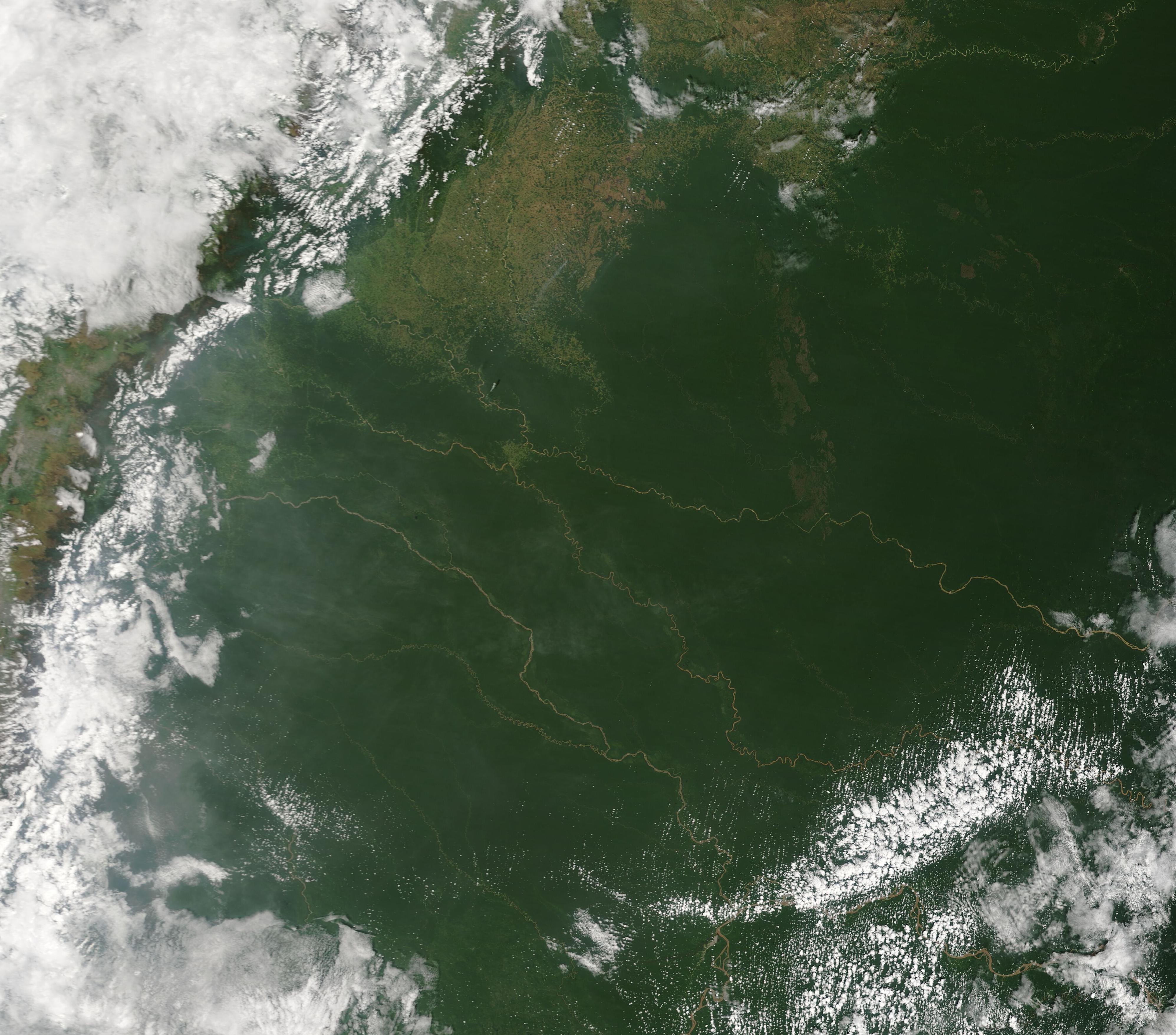
On January 3, 2022, the Moderate Resolution Imaging Spectroradiometer (MODIS) on board NASA’s Terra satellite acquired a true-color image of the Amazon. This view includes parts of Ecuador (southwest), Colombia (north) and Brazil (east). The Andes Mountains of Ecuador and Colombia can be seen near the left (west) edge of the image, with clouds covering the western face of the mountains. Numerous tan-colored rivers, rich with sediment, flow from the mountains into the rich, dense green of the rainforest.
Gray haze, suggestive of smoke from fires, hangs over the southwestern section of the image. While this image does not highlight the hot spots typical of actively burning fire, when thermal imagery is added as an overlay, it is clear that the gray haze is indeed smoke. The smoke rose from multiple fires burning in the agricultural areas (light green) near Florencia, Colombia. Many fires appeared to sit at the edge of the rainforest of that country, while others were in agricultural fields. According to Global Forest Watch, the fire season in Florencia generally begins in mid-January and lasts for ten weeks.
Image Facts
Satellite:
Terra
Date Acquired: 1/3/2022
Resolutions:
1km (709.4 KB), 500m (1.9 MB), 250m (1.3 MB)
Bands Used: 1,4,3
Image Credit:
MODIS Land Rapid Response Team, NASA GSFC
