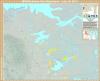
![The sparsity of the Canadian Shield
by u/repliers_beware
[[MORE]]“ The Canadian Shield is a geological formation surrounding Hudson Bay. The region is very inhospitable for agriculture as well as having harsh climates. I used a map of federal...](https://64.media.tumblr.com/36555cbdeea28f019bfced10a55724a8/ba9cb5030649b415-53/s1280x1920/29fbe331331104b4957056df794a8f00c9118c42.png)
The sparsity of the Canadian Shield
The Canadian Shield is a geological formation surrounding Hudson Bay. The region is very inhospitable for agriculture as well as having harsh climates. I used a map of federal districts to highlight the regions most effected by the shield. I used federal districts because I could find accurate populations/areas for them on Wikipedia and because they are are specifically drawn to include population centres, to satisfy the r/peopleliveincities crowd.
Related Posts


![Ethnic ancestry map of the US & Canada according to ancestry.com.
[[MORE]] RedSnowCastle:
This map was created through archived maps from ancestry.com of “A Genetic Census of America” and on Canada’s DNA.
British DNA is around 30% more common in...](https://64.media.tumblr.com/003c624713619ce0975dfa50dcf63a59/tumblr_pf5wcwVohU1rasnq9o1_100.png)
![Mapping U.S. State and Canadian Province data. Part 37: Passports.
[[MORE]] turbopony:
I am doing a series of maps to compare Canadian provinces with U.S. states. I hope you like them and if you have any ideas of maps you’d like to see, feel free to...](https://64.media.tumblr.com/d8488dae4f0e946906ffef5719d250c6/tumblr_pxrcddyYSw1rasnq9o1_100.png)