Day 7: Camper Bay to Thrasher Cove via Owen Point
We woke up before dawn and packed up everything in the dark. We knew that we had a fun day ahead of us, but only if we could make it around Owen Point while the tide was low enough. So, even though it was only about 10 km total distance, we also knew that we were really slow hikers. It would probably take us about six hours altogether, maybe more if the boulder-hopping we’d heard about was as difficult as they said. Low tide was 4.1 feet at 10am. We needed to complete the entire coastal section while the tide was below 8 feet, and get around Owen Point while it was below 6 feet. This gave us a fairly large window of opportunity, with 7 hours and 5 hours, respectively. We were fortunate, as a high tide in the middle of the day would have forced us to take the muddy forest trail, and we couldn’t have asked for better timing. I admit that I should have planned our trip around the tides, but I didn’t, and we just plain lucked out.

Just the same, we decided to err on the side of caution, by getting to the crux at Owen Point as early as possible. That’s how we ended up leaving camp at 6am, just as the sun came up. We hiked out as quietly as possible across the crunchy gravel beach past the tents of our neighboring campers. We were almost the only ones up that early.

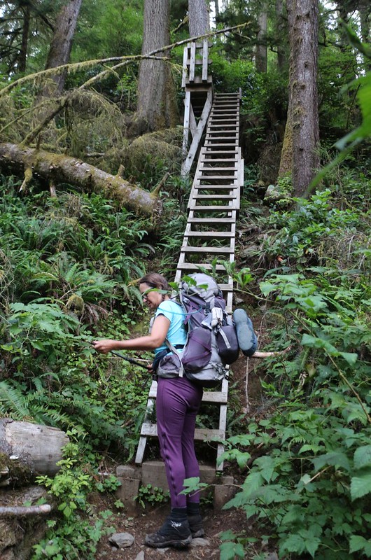
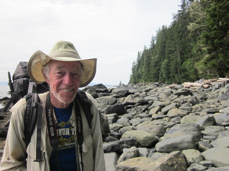
The first three kilometers of trail went through the forest, which, as always on the West Coast Trail, meant climbing up a few hundred feet of ladders. So up we went. Then we hiked on wooden walkways and fallen logs, avoided mud where we could, and crossed a few wooden bridges. We were fresh and the morning was cool. We had a fun time, and the forest was peaceful and beautiful, as always.
Video of Vicki making her way carefully down a sloping log trail with nailed-on steps

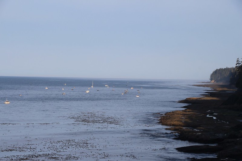
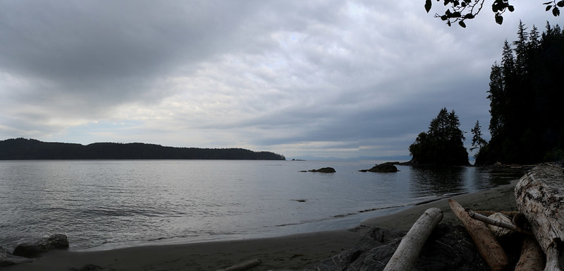
The trail gradually descended, and eventually we neared the coast again. We came upon a viewpoint, and looked out over the Straight of Juan de Fuca. Not far away was a veritable fleet of small boats, all of which were hoping to catch some salmon. The season had just started, and the rule was that they had to stay within a mile of the shore (most of the salmon made their migration out further) so the fishermen were all trolling slowly, hoping for luck. We could hear the throbbing of their diesel motors, and got a whiff of the exhaust every so often when the breeze shifted.
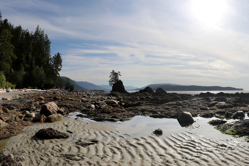
At the 65 km marker, we saw the collection of crab pots and buoys hanging from the trees that typically marked a beach access trail on the WCT. This one also had a sign: “Beach Access A.” This was where we wanted to go. We had left earlier than anyone, but just the same another group of six arrived just as we headed out onto the rocky shore. We were a bit annoyed at first, but that feeling quickly faded when we began taking photos for each other. We took them facing this way and that way. Both with my DSLR and my phone. With us as a couple and also separately. It was photo-op central. And then the faster group hiked onward as Vicki and I took up the rear. But we were used to that.
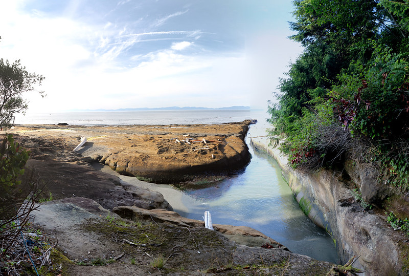
Step one: Head across the flat, seaweed-and-slime covered foreshore rocks toward the overhanging bluff. We hiked along it in the morning shadow, and were glad the tide was low. This would not be a good place to be at high tide, or during a storm!

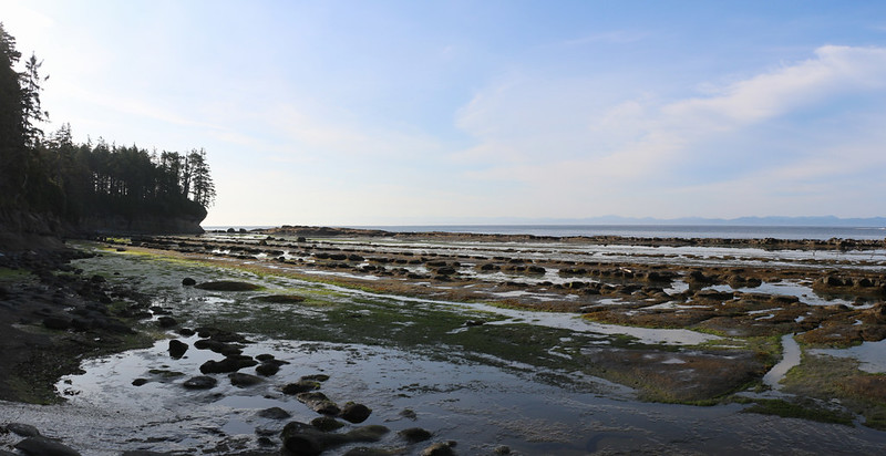

The next section was the part that Vicki was most interested in: Surge Channels. There were a whole bunch of them eroded into the coastal rock. Some were small enough to jump across, while others were large. But all of them had sea water surging through them every time a wave hit the shore. Two of them were so large that we had to go up into the forest on special trails (with buoy markers) in order to get around them. And they were a lot of fun to explore.


Video of a narrow surge channel with gurgling sounds
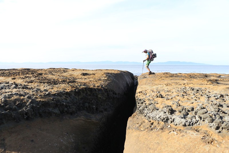

I checked the GPS and discovered that we were getting close to Owen Point, where the tide had to be below 6 feet. It was 9:30am, and low tide was arriving in another half hour. The moment of truth had arrived. What did Vicki want to do? Did she want to hike all the way back to Beach Access B, then climb up and over on the forest trail to Thrasher Cove? Or did she want to attempt the coastal route, with all the big boulders to climb across? I was totally in favor of the coastal option, especially after yesterday’s mud bog fiasco. The tide chart said we had five more hours to to hike three kilometers or so. But Vicki couldn’t decide, except that she knew she wanted to check out Owen Point and the Hole in the Rock. She would put off a decision until then. In the meantime, we headed for the point.
I texted one last photo of the two of us to family and friends. We were still using the U.S. cell towers across the straight, but once we turned the corner we would come into view of the Canadian towers, and I had no desire to pay extra for international service. I put the phone on “Airplane Mode” and put it in my pocket. The folks back home would have to wait until we were back on the hotel’s WiFi, two nights from now, to get word from us. We were officially Off the Radar.


The point itself wasn’t all that big a deal, just some flat rocks to walk across. But the views were excellent. And it was nice to finally see the end of our trek, Port Renfrew, far in the distance to the northeast. We’d be hiking there tomorrow.
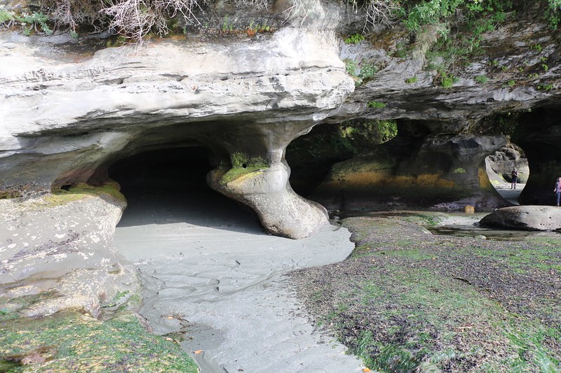
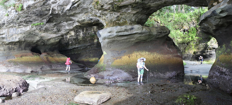
The best part of Owen Point was just around the corner: The Hole In/Under the Rock and its associated sea caves. These are truly extraordinary, not only in shape but in color. The constant rise and fall of the tides had eroded the limestone rock over the millennia, leaving behind caves and passages. It was the algae and sea flora that produced the amazing colors. Bright green and yellow and red layers had seemingly been painted on the walls of the caves. The tide was Nature’s Artist, its paint a living palette.
We took our time checking out the area. Another big group came up behind us, and yet other hikers had arrived from Thrasher Cove. Soon, there was a regular party going on. This made it difficult to get photos without humans in them, or photos of ourselves alone, but by being patient,we managed to do it. And everyone was marveling at the scenery. This, truly, was seriously cool, probably one of the best parts of the entire West Coast Trail.


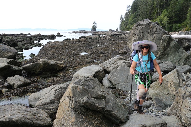
After we’d finished exploring the sea caves, it was time to make the final decision. Continue on the coast over big boulders, or head all the way back to the forest trail? We had about four and a half hours before the 8 foot tide limit, and two miles to hike. It seemed like a no-brainer to me, but it was Vicki’s decision. As more hikers arrived from Thrasher Cove, we asked them how hard it was, and how long it took them to get here. Most people said an hour to an hour and a half. But they were all young and fit. Two middle-aged women took about two hours, but one of them had slipped and hurt her knee. Vicki didn’t like the sound of that. And then a big guy showed up, all huffing and puffing, but happy to get to the point before the tide came in. We asked him how long it took. He said “It took me just over two and half hours, and I’m FAT!” and then he laughed. And that pretty much made our decision. We knew that we could easily make it, no matter how slow we hiked. And off we went.

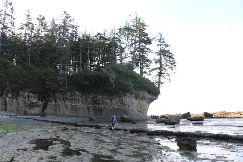
At first the hiking was easy, on wide shelves of flat rock. And the views were beautiful. I took lots of photos. But soon enough, the terrain began to change. We had arrived at the kilometers-long boulder field. This section turned out to be time consuming, but much easier than we expected. We were used to hiking on this sort of thing in the mountains, hiking cross-country over talus fields. Some of the rocks wobbled when stepped on, some of them sported a dangerous coating of slimy seaweed, while others were coated in tiny barnacles, which acted like grippy sandpaper on the soles of our boots. The real trick was in the route-finding, in avoiding the sliminess while remaining on firm footing. Except for the slime, we were old pros at this. In fact, we thought it was a whole lot of fun!


Video of Vicki swinging on a makeshift swing


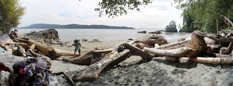
As it turned out, we were able to make it to to the Thrasher Cove campground in less than two and a half hours, with plenty of time to spare. The boulders continued almost all the way to camp, which we spotted after turning a corner to the left. The cove was protected by this small point from the bigger waves traveling down the huge inlet known as Port San Juan. (Port Renfrew was a tiny town on the shore of the body of water known as Port San Juan.) The cove was lined with a soft beach of sand, and there were lots of tents already in evidence, even though it was only noon.


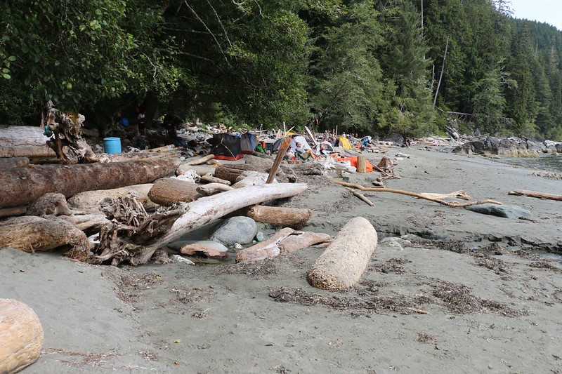
In fact, most of the good spots had already been taken, mainly by the people that passed us that morning. But we were used to that. In fact, we were quite happy with our progress that day, as this was the earliest we’d made camp all week! The weather was sunny, we were at a beautiful beach, and life was good. Vicki found a great spot further down the shore. We had one neighbor already, a young man visiting from Germany, but there really weren’t any spots much closer than him to our tent, thanks to the huge driftwood logs that divided most of the WCT campsites.
We plopped down our packs in the sand and got out some lunch to eat. First things first! We sat on a log in the shade and watched the small waves breaking on the beach. We eyed the boat traffic passing by just offshore, and amused ourselves with the antics of our neighbors, who were all having a great old time. Some folks were swimming, some eating food, others were tanning in the sun, and a few were collecting driftwood for fires that evening.


We set up the tent and put our gear inside. Then I headed off to the trickle of fresh water that made the camp a useful place to stay. Supposedly it stops running during dry years, but it was flowing just fine this time.
We had spoken to a number of new arrivals heading north, and they told us that it was supposed to rain that night, about 10mm or so. We were excited by this. Why? Well, it was simply because we were camping in the Pacific Northwest, the land of the temperate Rain Forest, and we thought that the trip wouldn’t be complete without a bit of proper rain. Besides, I’d purchased (and carried!) a 10 x 10 foot nylon tarp just for this eventuality. Vicki had even experimented with it at our house, and rigged it with lines and stakes for easy deployment. And the icing on the rainy cake was that it was our last night in the forest. No matter how wet we got, all we had to do was make it out to the bus stop at the end of the trail. We could worry about drying everything out back in San Diego! It was a perfect situation, to cap off a perfectly awesome week. So Vicki set up the tarp directly over the tent. That’s how they do it up here. She had a lot of fun rigging this up, and only asked me to hold a corner or a line in place a time or two. Mostly I just lay there in the shade reading my book. It doesn’t get better than that.


We hung out and relaxed for the rest of the day. We read our books. We met some new people, and said hello to others we’d met earlier that week. It was a very friendly crowd. As the afternoon headed into evening, the clouds began rolling in, and the sun was gone. We got dressed in warmer layers, and hung out some more. Eventually, Vicki cooked up our final meal of freeze-dried food. We sat on a log and ate our dinner. Then we put all of our remaining food into one nylon bag, whose volume was mostly trash from earlier meals, and we stowed it in the bear locker. We remembered how full and heavy our two food bags had been a week ago. We were happy that we had so little to carry tomorrow, when we would have to climb up and over the trail’s highest point, at 700 feet (213 meters) elevation.
We headed to bed early that evening. According to the guide book, tomorrow’s section of trail was extremely difficult, and the six kilometers of forest trail could easily take us six hours. The last boat across the Gordon River left at 3:30pm, and we had every intention of making it, even if we had to leave camp at the crack of dawn. Our bus, hotel, and plane reservations wouldn’t wait for us.
We also talked about the day we’d just had, and how it had been one of the best days of the entire trek. The surge channels, the sea caves, the boulder-hopping, and the perfect weather were even better than what we’d envisioned last Winter when we’d planned this trip.
And then we went to sleep, well before sunset, to the sound of gently breaking waves on the soft sands of Thrasher Cove.
For a topographic map of the hike see my CalTopo Page
For LOTS more photos of the trek see my Flickr Page
 << Back to Day 6 Onward to Day 8 >>
