Route Editor

| Guide | ♦ | 1 Triplog | 1 Topic |
details | drive | permit | forecast | route |
stats |
photos | triplog | topic | location |
| 36 | 1 | 1 |
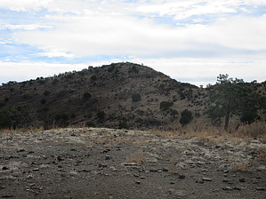
Come out of your shell and hike Turtle Mtn by DixieFlyer  Overview Turtle Mountain 7004 is a mountain in northeast Graham County. It has an elevation of 7,004 feet(duh!) and prominence of 2,004 feet, barely giving it status as a P2K peak. The summit, denoted as "Highest Peak" on topo maps, is right on the boundary between public land and San Carlos Apache land. There is a cadastral survey marker at the high point. Hike As described in this guide, this out-and-back hike begins and ends at the East Trailhead for the Old Safford-Morenci Trail - GET #13. The first 4 miles of the hike are on this trail, and then you make an off-trail ascent of Turtle Mountain.
Continuing on the trail through South Smith Canyon, you'll pass by a few signs that say "Trail" on them; after about 3 miles or so, you'll see a sign that says "Leaving Public Lands." Someone has pulled the sign up, and it was lying on the ground when the author of the guide saw it. There is not a "No Trespassing" or anything, and it is not apparent what land you are entering beyond this point; however, in looking at a map, it is obvious that you would be entering a sliver of San Carlos Apache Reservation land. After being on the trail for about 4 miles, you'll go off-trail toward the Turtle Mountain summit. The summit is almost due south, but if you follow the default route for this guide, you'll loop around a bit to the west on a ridgeline at the head of South Smith Canyon. There is no real bushwhacking, per se, and you'll pick your way around some high desert vegetation. The climb is a bit steep, and you'll gain 1,000 feet in elevation over 0.8 miles. The terrain is a bit rocky but not too bad; basically, the off-trail ascent is nothing more than a class 2 hike. You go along a ridgeline on or near the reservation boundary, and you can often follow some game trails along the way. You may see some cattle not too far below the summit, so if a cow can make the climb up there, most hikers can also get there. The grade eases up a bit as you get closer to the summit, and you'll hike up to the summit on the northwest slope of the peak. At the summit, you'll see a benchmark, two reference marks, and the aforementioned cadastral survey marker that marks the boundary between public land and the reservation. The benchmark and reference marks are on the public land side, just a few feet from the boundary. The 360-degree summit views are outstanding, and, IMHO, rival those of any peak in Arizona. After enjoying the scenery at the summit, return to the trailhead the same way that you came up. Red Tape According to the Bureau of Land Management(BLM), the Old Safford-Morenci Trail crosses Arizona state trust land one mile from the trailhead. As such, a recreational permit from the Arizona State Land Office should be obtained. A short section of the Old Safford-Morenci Trail crosses into an isolated, remote area of the San Carlos Apache Reservation, and part of the off-trail route to the summit also crosses into the reservation. Thus, a San Carlos Apache Tribal recreation permit should also be obtained. Check out the Official Route and Triplog. Leave No Trace and +Add a Triplog after your hike to support this local community. | ||||||||||||||||||||||||||||||||||||||||||||||||||||||||||||||||||||||||||||||||||||||||||||