File:Uruguay Tourist Regions map.svg
Jump to navigation
Jump to search

Size of this PNG preview of this SVG file: 522 × 600 pixels. Other resolutions: 209 × 240 pixels | 418 × 480 pixels | 668 × 768 pixels | 891 × 1,024 pixels | 1,783 × 2,048 pixels | 1,445 × 1,660 pixels.
Original file (SVG file, nominally 1,445 × 1,660 pixels, file size: 1.39 MB)
Captions
Captions
Add a one-line explanation of what this file represents
Summary[edit]
| Description |
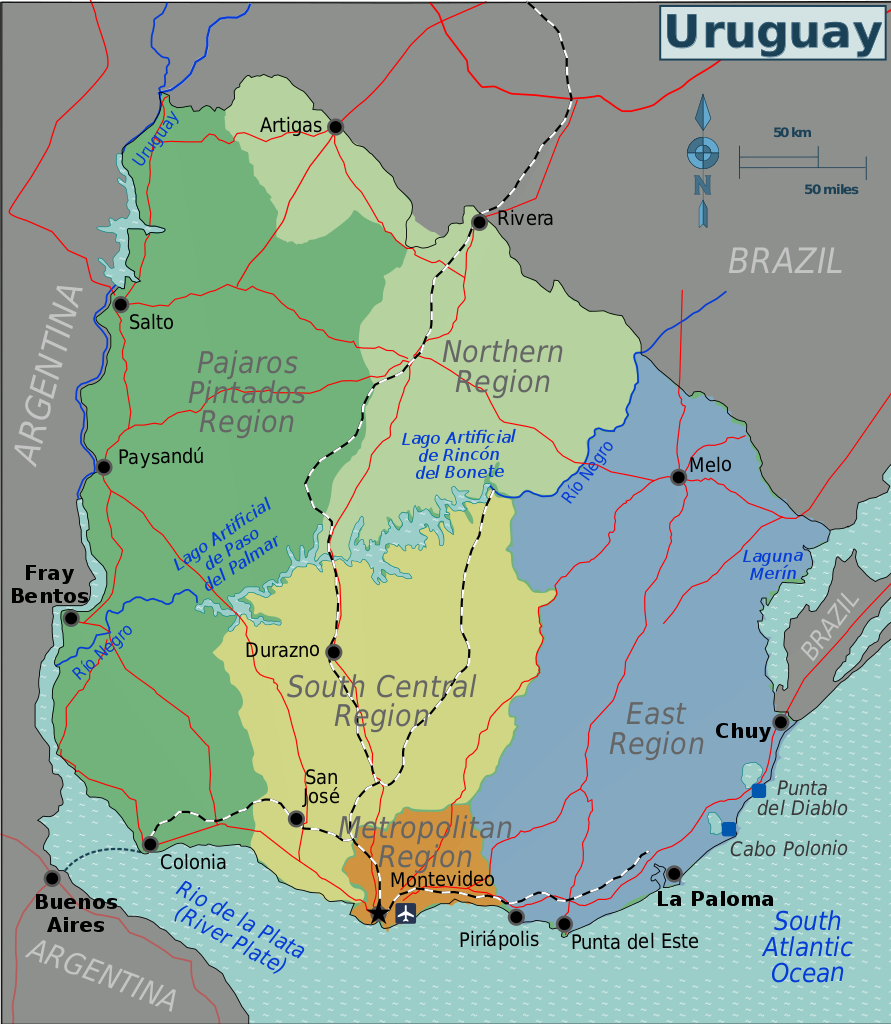
English: Uruguay tourist regions map, fixed according to the tourist regions described by the Minisitry of Tourism of Uruguay (http://turismo.gub.uy/index.php/en/places-to-go).
Español: Mapa de regiones turísticas del Uruguay, corregido según las regiones turísticas descritas por el Ministerio de Turismo de Uruguay (http://turismo.gub.uy/index.php/que-hacer). |
| Date | |
| Source | Based on File:Uruguay Regions map.svg by Wikitravel user Burmesedays and uploaded to Wikivoyage-old, which in turn is based on a map of the Perry-Castañeda Library Map Collection (the Library of the University of Texas). National routes fixed according to File:RutasNacionalesUruguay.svg by CITY MVD. |
| Author | Zerabat |
| Other versions |
|
| SVG development | This vector image was created with Inkscape, or with something else. |

Licensing[edit]
This file is licensed under the Creative Commons Attribution-Share Alike 3.0 Unported license.
- You are free:
- to share – to copy, distribute and transmit the work
- to remix – to adapt the work
- Under the following conditions:
- attribution – You must give appropriate credit, provide a link to the license, and indicate if changes were made. You may do so in any reasonable manner, but not in any way that suggests the licensor endorses you or your use.
- share alike – If you remix, transform, or build upon the material, you must distribute your contributions under the same or compatible license as the original.
File history
Click on a date/time to view the file as it appeared at that time.
| Date/Time | Thumbnail | Dimensions | User | Comment | |
|---|---|---|---|---|---|
| current | 14:53, 11 May 2017 | | 1,445 × 1,660 (1.39 MB) | ZrbtWm (talk | contribs) | Corrijo división entre las regiones "Norte" y "Pájaros pintados". |
| 22:40, 7 February 2017 |  | 1,445 × 1,660 (1.38 MB) | ZrbtWm (talk | contribs) | {{Information |Description ={{en|1=Uruguay tourist regions map, fixed according to the tourist regions described by the Minisitry of Tourism of Uruguay (http://turismo.gub.uy/index.php/en/places-to-go).}} {{es|1=Mapa de regiones turísticas del Urug... |
You cannot overwrite this file.
File usage on Commons
The following 2 pages use this file:
File usage on other wikis
The following other wikis use this file:
- Usage on en.wikivoyage.org
- Usage on es.wikipedia.org
- Usage on es.wikivoyage.org