File:Andorra topographic map-ca.svg

Original file (SVG file, nominally 1,625 × 1,300 pixels, file size: 1.58 MB)
Captions
Captions
| Camera location | | View this and other nearby images on: OpenStreetMap |
|---|
| Description |
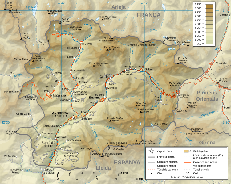
Català: Mapa topogràfic d'Andorra en versió en català English: Topographic map in Catalan of Andorra Français : Carte topographique en catalan de l'Andorre |
| Date | (UTC) |
| Source |
Català: Traducció de Andorra_topographic_map-fr.svg
L'original té les dades topogràfiques de la Missió NASA Shuttle Radar Topography (SRTM3 v.2) (domini públic) editat amb 3DEM i dlgv32 Pro i vectoritzat amb l'Inkscape; projecció UTM; WGS84 datum; relleu ombrejat (imatge composta de posicions lluminoses de NO, O i N). Referència per les dades addicionals:
Escala aproximada de les dades topogràfiques: 1:400.000 (precisió: uns 100 m); Nota: El relleu ombrejat és una imatge rastrejada immersa en el fitxer SVG. English: Translation from Andorra_topographic_map-fr.svg
Topographic data from the NASA Shuttle Radar Topography Mission (SRTM3 v.2) (public domain) edited with 3DEM and dlgv32 Pro and vectorized with Inkscape; UTM projection; WGS84 datum; shaded relief (composite image of N-W, W and N lightning positions); Reference used for the additional data:
Approximate scale of topographic data: 1:400,000 (accuracy: about 100 m); Note : The shaded relief is a raster image embedded in the SVG file. Français : Traduction d'Andorra_topographic_map-fr.svg
Données topographiques de la NASA Shuttle Radar Topography Mission (SRTM3 v.2) (domaine public) éditées avec 3DEM et dlgv32 Pro et vectorisées avec Inkscape ; projection UTM ; WGS84 datum ; relief ombré (image composite d'éclairages du N-O, O et N) ; Références utilisées pour les données complémentaires :
Échelle approximative des données topographiques : 1:400 000 (précision : environ 100 m) ; Note : Le relief ombré est une image bitmap embarquée dans le fichier SVG. Approximate geographic limits of the map (3" close):
|
| Author |
|
| Other versions |
[]
|


|
Permission is granted to copy, distribute and/or modify this document under the terms of the GNU Free Documentation License, Version 1.2 or any later version published by the Free Software Foundation; with no Invariant Sections, no Front-Cover Texts, and no Back-Cover Texts. A copy of the license is included in the section entitled GNU Free Documentation License. |
- You are free:
- to share – to copy, distribute and transmit the work
- to remix – to adapt the work
- Under the following conditions:
- attribution – You must give appropriate credit, provide a link to the license, and indicate if changes were made. You may do so in any reasonable manner, but not in any way that suggests the licensor endorses you or your use.
- share alike – If you remix, transform, or build upon the material, you must distribute your contributions under the same or compatible license as the original.

|
This SVG file contains embedded text that can be translated into your language, using any capable SVG editor, text editor or the SVG Translate tool. For more information see: About translating SVG files. |
Original upload log[edit]
This image is a derivative work of the following images:
- Image:Andorra_topographic_map-fr.svg licensed with Cc-by-sa-3.0,2.5,2.0,1.0
- 2008-06-12T20:03:47Z Sting 1625x1300 (1654623 Bytes) Correction on a name.
- 2008-03-07T14:37:41Z Sting 1625x1300 (1654334 Bytes) Improved shaded relief and other details
- 2008-02-28T04:26:38Z Sting 1625x1300 (1275242 Bytes) {{Location|42|33|00|N|01|36|00|E|scale:200000}} {{Information |Description={{en|Topographic map in French of [[:Category:Andorra|Andorra]]}}{{fr|Carte topographique en français de l'[[:Category:Andorra|Andorre]]}} |Source={
Uploaded with derivativeFX
File history
Click on a date/time to view the file as it appeared at that time.
| Date/Time | Thumbnail | Dimensions | User | Comment | |
|---|---|---|---|---|---|
| current | 19:00, 26 October 2010 | | 1,625 × 1,300 (1.58 MB) | SMP (talk | contribs) | topònim actualitzats amb el nomenclàtor d'Andorra de 2010 |
| 11:46, 2 September 2008 |  | 1,625 × 1,300 (1.58 MB) | SMP (talk | contribs) | {{Information |Description= |Source= |Date= |Author= |Permission= |other_versions= }} | |
| 15:30, 1 September 2008 |  | 1,625 × 1,300 (1.36 MB) | SMP (talk | contribs) | {{Information |Description={{ca|Mapa topogràfic d'Andorra en versió en català}}{{en|Topographic map in Catalan of Andorra}}{{fr|Carte topographique en catalan de l'Andorre}} |Source=*[[:Image:Andorra_topographic_map- |
You cannot overwrite this file.
File usage on Commons
The following 12 pages use this file:
- Atlas of Andorra
- File:Andorra topographic map-ca.svg
- File:Andorra topographic map-de.svg
- File:Andorra topographic map-en.svg
- File:Andorra topographic map-fr.svg
- File:Andorra topographic map-hu.svg
- File:Andorra topographic map-it.svg
- File:Andorra topographic map-mk.svg
- File:Andorra topographic map-pl.svg
- File:Andorra topographic map-ptbr.svg
- File:Andorra topographic map-sr.svg
- Template:Other versions/Andorra topographic map
File usage on other wikis
The following other wikis use this file:
- Usage on an.wikipedia.org
- Usage on az.wikipedia.org
- Usage on ca.wikipedia.org
- Usage on co.wikipedia.org
- Usage on en.wikipedia.org
- Usage on es.wikipedia.org
- Usage on fi.wikipedia.org
- Usage on fr.wikinews.org
- Usage on id.wikipedia.org
- Usage on ja.wikipedia.org
- Usage on oc.wikipedia.org
- Usage on pt.wikipedia.org
- Usage on simple.wikipedia.org
- Usage on sl.wikipedia.org
- Usage on vi.wikipedia.org
- Usage on www.wikidata.org