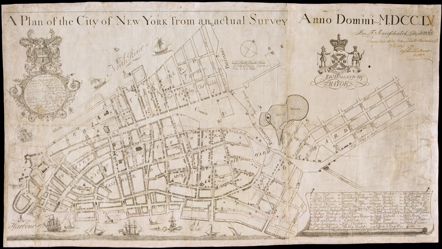
A plan of the City of New York from an actual survey anno domini MDCCLV
This map is also available in American Revolutionary Geographies Online (ARGO), a collections portal especially built for material relating to the American Revolutionary War Era. Visit ARGO to learn more about this item and explore the historical geography of North America in the late eighteenth century.
Item Information
- Title:
- A plan of the City of New York from an actual survey anno domini MDCCLV
- Cartographer:
- Maerschalck, Francis W., -1776
- Printer:
- Duyckinck, G.
- Dedicatee:
- De Lancey, James, 1703-1760
- Name on Item:
-
by F. Maerschalck
- Date:
-
1755
- Format:
-
Maps/Atlases
- Location:
- New-York Historical Society
- Collection (local):
-
New-York Historical Society Collection
- Subjects:
-
Lower Manhattan (New York, N.Y.)--Maps
Battery Park (New York, N.Y.)--Maps
Wall Street (New York, N.Y.)--Maps
South Street Seaport District (New York, N.Y.)--Maps
Civic Center (New York, N.Y.)--Maps
Lower East Side (New York, N.Y.)--Maps
TriBeCa (New York, N.Y.)--Maps
Two Bridges (New York, N.Y.)--Maps
Delancey Street District (New York, N.Y.)--Maps
Little Italy (New York, N.Y.)--Maps
Manhattan (New York, N.Y.)--Maps
Chinatown (New York, N.Y.)--Maps
City walls--New York (State)--New York--Maps
Piers--New York (State)--New York--Maps
Ponds--New York (State)--New York--Maps
Fortification--New York (State)--New York--Maps
Church property--New York (State)--New York--Maps
Synagogues--New York (State)--New York--Maps
Markets--New York (State)--New York--Maps
Landowners--New York (State)--New York--Maps
Buildings--New York (State)--New York--Maps
- Places:
-
New YorkManhattan
- Extent:
- 1 map : ill. ; 48 x 85 cm
- Terms of Use:
-
No known copyright restrictions.
No known restrictions on use.
- Publisher:
-
[New York] :
printed, ingraved for and sold by G. Duyckinck
- Scale:
-
Scale [1:3,300]
- Language:
-
English
- Catalog Record:
-
https://library.nyu.edu/persistent/lcn/nyu_aleph001593156?institution=NYU&persistent
- Notes:
-
Covers Manhattan, New York (N.Y.) below Delancey Street. Shows political divisions, fortifications, some buildings and natural features. The map also locates churches, markets, and public squares.
Dedication: "To the Honourable JAMES DE LANCEY, Esqr, Lieutenant Governor and Commander In Chief In and over the Province of NEW YORK and territories depending thereon In America This Plan of the City of NEW YORK Is Humbly dedicd. By your Honours Most Obet. & Humble Servent G. Duyckinck."
Illustrated: city coat of arms, ships, dedicatory cartouche "certum voto pete finum."
Ink on paper.
Includes key to buildings.
- Notes (citation):
-
Stokes, I.N. Phelps. Iconography of Manhattan Island, v. 1, p. 274-275 and pl. 34.
Cohen, Paul E. and Robert T. Augustyn. Manhattan in Maps. NY: Rizzoli, 1997, p. 64-65.
- Identifier:
-
2731_MaerschalkPlan